")
OpenLitterMap.com – Open Data on Plastic Pollution with Blockchain Rewards (Littercoin)
Open Geospatial Data, Software and Standards volume 3, Article number: 6 (2018 ) Cite this article
OpenLitterMap rewards users with Littercoin for producing open data on litter. Open data on the geospatial characteristics of litter provide means of invoking and evaluating responses to plastic pollution. OpenLitterMap currently works as a web app on all devices with native mobile apps in development. The stack includes the integration of the Laravel PHP Framework on the backend; Vue for frontend reactivity; NativeScript-Vue for mobile apps; Bulma for CSS; Leaflet for web-mapping; Turf.js for geospatial analysis; the Ethereum Blockchain for tokenization; Stripe; ChartJS; AWS; and more. Anywhere from a single cigarette butt to the contents of an entire beach or street clean can be logged in a single geotagged photo. Alternatively, a simple index may be used if litter is incalculable. The open data includes an increasing 100+ pre-defined types of litter; 20+ corporate brands; verification status; coordinates; timestamp; phone model; the latest OpenStreetMap address at each location; and the litter presence as a Boolean. To date, 100% of all submitted data (~ 8200 photos, ~ 28,000 litter from over 150 contributors) has been manually verified which is being used to develop machine learning algorithms.
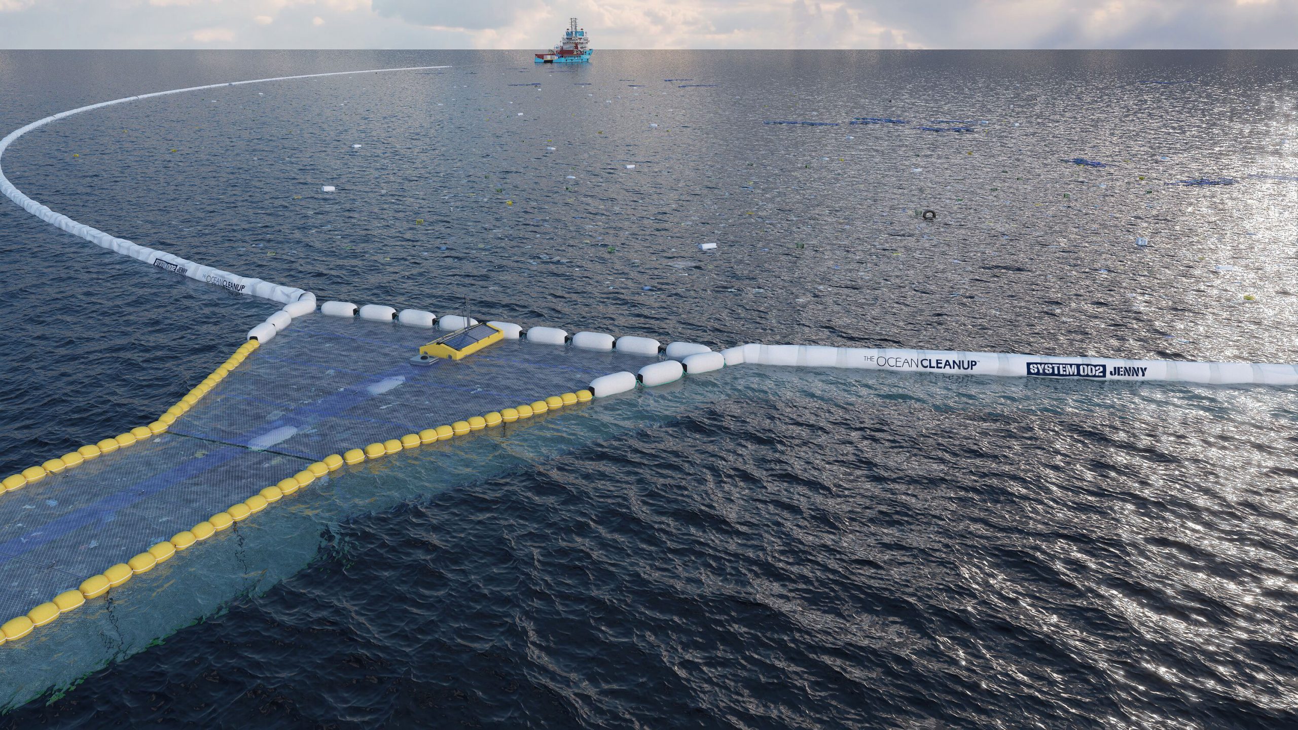
Human activities on the environment have been so severe that we (humans) have literally defined the “Anthropocene” [27]. The Anthropocene is the latest epoch in the geologic history of the Earth, characterised exclusively by humans’ impact on the environment. Although there are many factors involved (e.g. climate change, deforestation, etc.), perhaps nothing characterises the Anthropocene more than plastic pollution, which was first recognized to have a global distribution in the marine environment as early as 1975 [21]. In cities, nicotine has become a recognized pollutant of urban waters because of the trillions of plastic-tipped cigarette butts dropped around the world [9]. Since the beginning of commercial plastic production in the 1950s, the annual global production of plastic rose to 30-million tonnes by 1988 and to 280–299 million tonnes by 2014 [19, 26]. In this time we have embedded plastic, potentially permanently, right across our only habitable planet. Recent research from The Ocean CleanupFootnote 1 in the Pacific Ocean suggests that the “Great Pacific Garbage Patch”, the largest accumulation of plastic in the oceans, spans an area of about 1.6 million km2 weighing about 80,000 t, which is 4 and 16 times larger than previous estimates and is now said to be rapidly accumulating more plastic [16]. On land, litter, or plastic pollution, costs taxpayers millions in many countries every year for cleanup intervention and management as well as potentially infinitely more in biodiversity and ecosystem service loss. The UNEP [26] reports that globally, 22–43% of plastic is disposed of in landfills, which have a limited capacity thus increasing the costs of waste management and waste security over time. The World Bank estimated that this quantity of waste and its related cost will likely double from 2012 to 2025 [11]. Despite most plastic originating on land, plastic pollution is now one of the most serious threats for healthy marine ecosystem functioning [1, 14, 20, 25, 26]. Traditionally, because of spatial and temporal restrictions, it was only possible for scientists to make inferences on the spatial distribution of litter based on small samples of data. Today, hundreds of millions of people are equipped with incredibly accurate geospatial data collectors, which can be used to map and crowdsource geospatial data not just on plastic pollution, but to some extent, the litter caused by the products and economic activity of a handful of global corporations. Depending on the nature of projects and the data collection methods, this crowdsourcing of data is commonly referred to as Citizen Science [13] and Volunteered Geographic Information (VGI). Crowdsourced data is a paradigmatic shift in how knowledge, particularly that of a geospatial nature, is created and shared throughout society [7]. The need for geospatial information to mitigate and raise awareness about our plastic footprint is urgent. In 2010 alone, it has been estimated that between 8 and 12 million tonnes of plastic and other types of waste entered the oceans. If current trends continue, this figure is expected to continue to increase exponentially potentially reaching ~ 70 million tonnes by 2025 [14]. Some authors have estimated that 90% of plastic waste entering the ocean is from just 10 rivers. However, the same authors acknowledge there are large uncertainties with these estimates because of a lack of data [23]. The Ocean Cleanup estimate the annual global input of plastic into the ocean by rivers is between 1.15–2.41 million tonnes, acknowledging that the top 20 polluting rivers are primarily located in Asia, which the authors account for up to 67% of the global input [17]. However, these studies focus largely on population and waste management metrics and because of a lack of geospatial data on plastic pollution, these approaches may be largely unable to appropriately characterize contemporary anthropogenic litter [12].


/https://public-media.si-cdn.com/filer/2d/f8/2df8565b-846e-47d1-b139-ce52095fb8da/37437678176_efd04bd9e4_o_web.jpg)