Recent records of thermohaline profiles and water depth in the Taam ja’ Blue Hole (Chetumal Bay, Mexico)
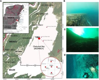
Coastal karst structures have been recently explored and documented in Chetumal Bay, Mexico, at the southeast of the Yucatan Peninsula. These structures, recognized as blue holes, stand out for their remarkable dimensions within a shallow estuarine environment. Particularly the Taam Ja’ Blue Hole (TJBH), revealed a depth of ~274 mbsl based on echo sounder mapping, momentarily positioning it as the world's second-deepest blue hole. However, echo sounding methods face challenges in complex environments like blue holes or inland sinkholes arising from frequency-dependent detection and range limitations due to water density vertical gradients, cross-sectional depth variations, or morphometric deviations in non-strictly vertical caves. Initial exploration could not reach the bottom and confirm its position, prompting ongoing investigation into the geomorphological features of TJBH. Recent CTD profiler records in TJBH surpassed 420 mbsl with no bottom yet reached, establishing the TJBH as the deepest-known blue hole globally. Hydrographic data delineated multiple water layers within TJBH. Comparison with Caribbean water conditions at the Mesoamerican Barrier Reef System, reef lagoons, and estuaries suggests potential subterranean connections. Further research and implementation of underwater navigation technologies are essential to decipher its maximum depth and the possibilities of forming part of an interconnected system of caves and tunnels.

